Tracking degradation from space
Metadata
collection
identifier
303b5dd2-fc09-4390-a9b8-9b450d0f82be
creator
type
coverage
description
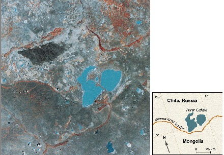
Satellite image (Landsat, October 1989) of the border between the Russian district of Chita and northeastern Mongolia. Lakes are blue, areas with the most vegetation are red, greens and grays indicate intermediate amounts of vegetation, and pale and white areas are sandy and bare earth. In the northern (Russian) half of the image, the land is lighter in color, scarred, and marked where the thin topsoil has been exposed or covered with drifting sand. In the southern (Mongolian) half of the image, the vegetation cover is much more uniform. (Inset) A map is given for comparison.
publisher
Science
source
DOI: 10.1126/science.281.5380.1147
Sneath, David. “State Policy and Pasture Degradation in Inner Asia”. Science 21 Aug 1998: Vol. 281, Issue 5380, pp. 1147-1148.
rights
© 1998 American Association for the Advancement of Science
subject
date
1998
language
files
| metadata-en | docx | 81.1 KiB | 2018-03-16 16:40:59 |
